
Severe Storms Target Midwest and Plains
Severe Storms Target Midwest and Plains in what forecasters warn could become a prolonged and dangerous weather event. Over the coming days, residents across the region should prepare for intense thunderstorms, large hail, damaging winds, and the strong possibility of tornadoes. This multiday threat is expected to intensify through early next week, affecting millions across the central United States.
Tornadoes and Severe Thunderstorms Expected Through Tuesday
A prolonged outbreak of severe storms is underway. It will first affect the Great Lakes and Midwest through the end of the week. Over the weekend, the threat will shift to the Great Plains, with conditions remaining dangerous into early next week.
The most severe storms may bring:
- Tornadoes, including some that could be strong (EF2 or higher)
- Large hail up to golf ball size or larger
- Damaging winds that could exceed 75 mph
Latest Tornado Reports
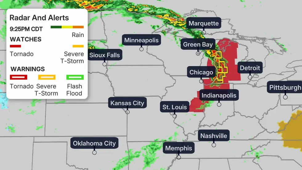
As of Thursday, a number of tornadoes had already been confirmed. One swept through a barn and destroyed a house, and another within the area of New Richmond, Wisconsin.
A rotating wall cloud downtown in Minneapolis earlier Thursday made a tornado warning. Pea-sized hail occurred in Rogers, a northwest suburb.
Forecast Breakdown by Day
(This shows the likelihood of severe thunderstorms, according to NOAA’s Storm Prediction Center.)
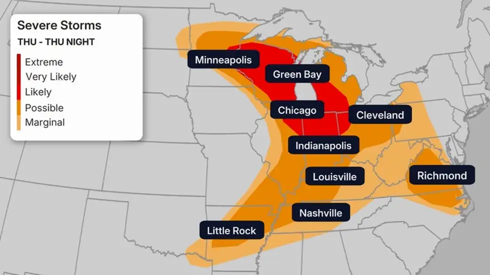
Thursday Night
Areas most at risk include:
- East-central Minnesota
- Much of Wisconsin
- Northeast Illinois
- Northern Indiana
- Western Michigan
- Northwest Ohio
Cities such as Chicago and Milwaukee lie in the high-risk zone. Severe storms in this area may include:
- Golf ball-sized hail or larger
- Damaging straight-line winds
- Tornadoes, some possibly strong
The risk is more isolated farther south into the Ohio Valley. But any storm that forms there could still bring damaging winds, hail, and tornadoes.
Friday Through Friday Night
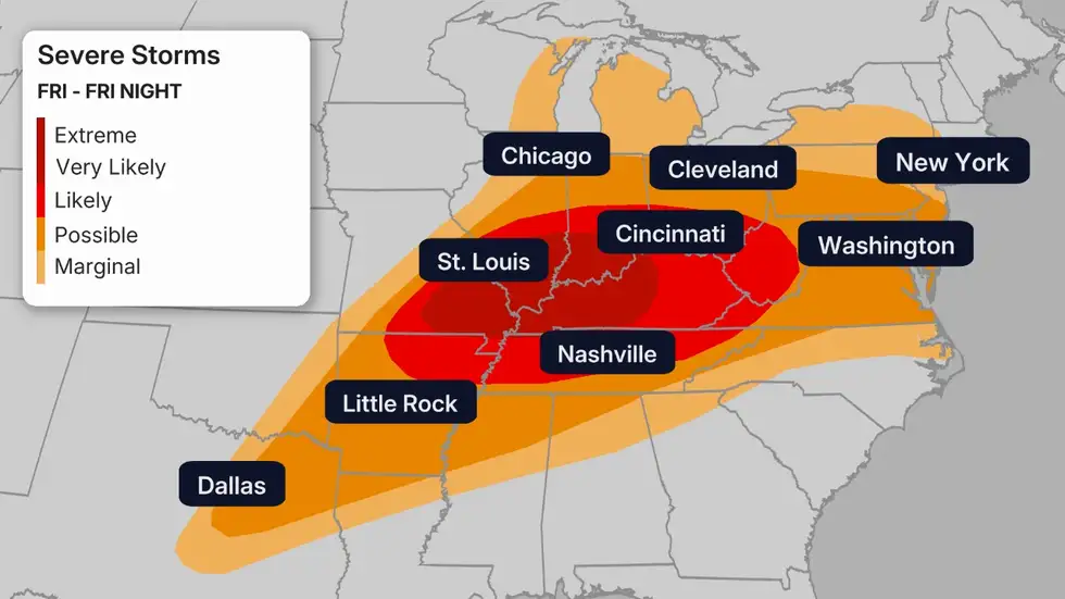
(This shows the likelihood of severe thunderstorms, according to NOAA’s Storm Prediction Center.)
A potentially widespread outbreak of severe weather is expected in the:
- Ohio Valley
- Mid-Mississippi Valley
Cities at high risk include Indianapolis, Louisville, Cincinnati, Nashville, and St. Louis.
Expected threats:
- Hail larger than golf balls
- Winds over 75 mph
- Strong tornadoes
Particularly dangerous conditions may develop from southeast Missouri to western and central Kentucky, where widespread wind damage could lead to power outages and downed trees.
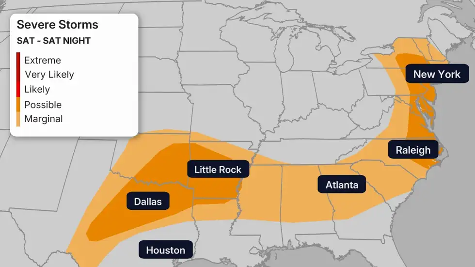
Saturday
Scattered severe storms could affect a broad region, including:
- New York to North Carolina
- The southern states, especially Texas, Oklahoma, and Arkansas
Sunday to Monday
(This shows the likelihood of severe thunderstorms, according to NOAA’s Storm Prediction Center.)
The most intense severe weather threat shifts to the Central and Southern Plains, targeting:
- Kansas
- Oklahoma
- Northern Texas
Cities to watch closely include:
- Dallas-Fort Worth
- Oklahoma City
- Tulsa
- Wichita
These storms may bring:
- Large hail
- Damaging winds
- Strong tornadoes
While details are still developing, the setup points to a significant outbreak of severe thunderstorms over one or more days between Sunday and Tuesday.
Tuesday
Severe weather may move eastward into:
- The Ark-La-Tex region
- The mid-Mississippi Valley
More updates will become available in the coming days. Stay tuned to The Weather Channel app or weather.com for live updates.
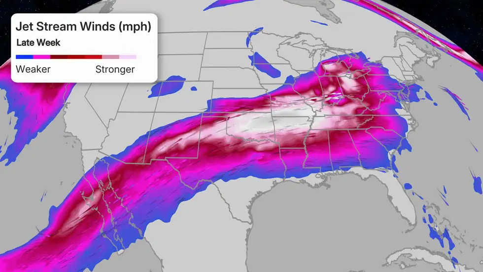
Why This Pattern Is So Dangerous
(This shows the likelihood of severe thunderstorms, according to NOAA’s Storm Prediction Center.)
A strong jet stream dipping southward into the central U.S. will intensify by Friday. This pattern pulls warm, humid air from the Gulf of Mexico northward into the Plains and Midwest.
Combined with upper-level winds, this clash of air masses creates the ideal recipe for severe thunderstorms.
May is already the peak season for tornadoes in these regions. This evolving setup raises concerns for multiple strong and long-lived tornadoes.
Stay Prepared
- Review your severe weather safety plans
- Identify nearby shelter locations, especially if you don’t have a basement
- Prepare for the possibility of extended power outages from wind damage
For tips on staying safe, see Tornado Safety Tips and What to Do If You Don’t Have a Basement.
As severe storms target the Midwest and Plains over the next several days, staying informed and prepared is crucial. Weather conditions can change rapidly, bringing threats like hail, damaging winds, and tornadoes. Keep monitoring updates from trusted sources and follow safety guidelines to protect yourself and your loved ones. For more detailed advice on how to stay safe during severe weather, visit our Tornado Safety Tips page. Remember, preparedness saves lives.
