
Hurricane Erin Threatens US East Coast and Bermuda
Journey Tribune — Hurricane Erin threatens US East Coast and Bermuda as it rapidly intensifies into a massive Category 4 storm over the Atlantic Ocean. While the hurricane is not expected to make direct landfall, its powerful winds are already driving dangerous rip currents, towering waves, and coastal flooding risks from the Carolinas to New Jersey, while also impacting Puerto Rico and the Bahamas.
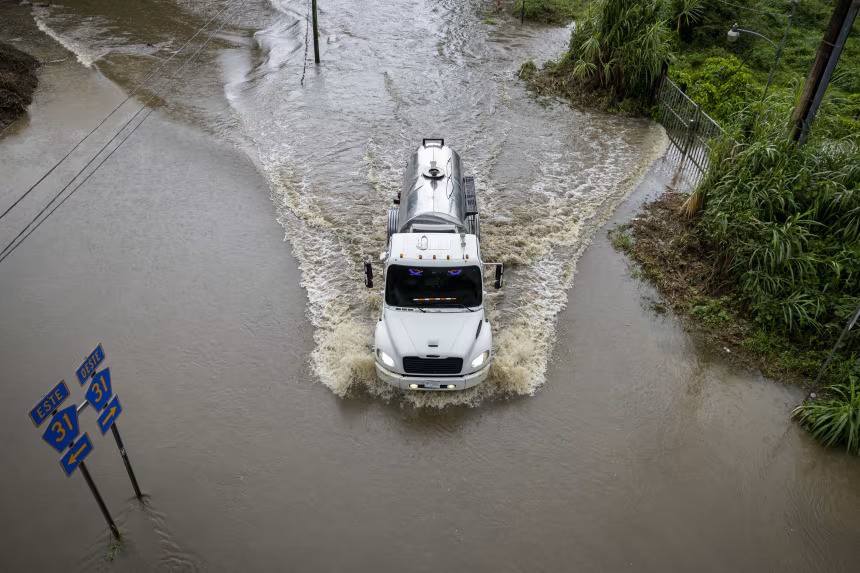
Puerto Rico Hit Hard: Heavy Rain, Flooding, and Power Cuts
Erin first unleashed its outer rain bands on Puerto Rico late Saturday, inundating streets, triggering flash floods, and leaving thousands stranded. By Sunday, Governor Jennifer González-Colón confirmed that more than 100,000 households were without power, while emergency crews scrambled to restore electricity and clear blocked roads.
The National Weather Service (NWS) placed the island under a flood watch through Monday evening, warning of additional rainfall of up to two inches. With soil already oversaturated, the risk of landslides and mudslides looms large in mountainous regions.
Bahamas and Turks and Caicos Face Rising Danger
Beyond Puerto Rico, Erin’s outer bands began sweeping into the Turks and Caicos Islands and the southeastern Bahamas early Monday. Meteorologists warn of rainfall totals between 4 to 6 inches, with isolated higher amounts.
The National Hurricane Center (NHC) has issued tropical storm warnings for Turks and Caicos and parts of the southeastern Bahamas. Meanwhile, a tropical storm watch was declared for the central Bahamas as Erin’s influence expands. Residents in low-lying areas are being advised to move to higher ground, prepare for power outages, and avoid coastal zones where flooding and large waves are likely.
East Coast US: Massive Waves and Rip Currents Incoming
Although Erin’s core will remain offshore, the system’s enormous footprint is what worries forecasters most. Erin is already pushing swells hundreds of miles outward, and by Tuesday, August 19, 2025, those swells will collide with the US East Coast.
Coastal areas from South Carolina northward through Virginia, Maryland’s Eastern Shore, Delaware, and New Jersey will face a spike in rip current risks. The danger is expected to persist through Thursday, August 21, 2025.
The National Weather Service office in Morehead City, North Carolina, issued a stark warning:
“Even though Erin is expected to remain far offshore, the threat to life from rip currents and high surf along our beaches is very real. We strongly advise beachgoers to stay out of the water.”
Local authorities are preparing accordingly. In Dare County, North Carolina, home to the famous Outer Banks, officials issued a local state of emergency and a mandatory evacuation order for Hatteras Island. Flooding and overwash from the Atlantic are expected to make N.C. Highway 12 is impassable for several days.
Bermuda Braces for Severe Seas
Farther out in the Atlantic, Bermuda sits directly within Erin’s path of influence. Forecasts call for tropical storm–force winds and extremely rough seas later this week. Local emergency managers warn residents and visitors to secure property, avoid boating, and prepare for hazardous conditions even if the storm remains well offshore.
Rip Currents: A Leading Weather Killer in the US
Rip currents—powerful channels of fast-moving water that can drag swimmers away from shore—are a silent but deadly threat. According to the National Weather Service, 44 people have died in the US in 2025 alone due to rip currents and surf-zone hazards.
Over the past decade, rip currents have killed more people annually than lightning, tornadoes, or even hurricanes making direct landfall. Officials along the East Coast are reminding tourists that sunny skies do not mean safe waters.
“This is not the week to swim in the ocean,” the Dare County Emergency Management office emphasized. “The risk from surf and flooding will be life-threatening.”
Beach patrols and lifeguards are preparing for large crowds, but warn that they may have to close beaches if conditions worsen.
Rapid Intensification: A Record-Breaking Hurricane
What makes Erin extraordinary is its speed of intensification. In just over 24 hours, Erin jumped from a tropical storm to a Category 5 hurricane, with winds peaking at 165 mph (265 km/h) on Saturday.
This explosive growth ranks among the fastest intensifications ever recorded in the Atlantic. Scientists say Erin fed on abnormally warm Atlantic waters—some of the warmest ever observed in mid-August—combined with atmospheric conditions that acted like a “supercharger.”
After undergoing an eyewall replacement cycle, the storm temporarily weakened to Category 3. But by Monday, Erin had re-strengthened to Category 4, now with a broader wind field capable of producing widespread impacts far from its center.
Such rapid intensification events are becoming more common in a warming climate. Rising ocean temperatures provide more fuel for hurricanes, allowing them to strengthen faster and reach higher categories than in previous decades.
The Bigger Picture: 2025 Hurricane Season Is Just Beginning
Erin is officially the first hurricane of the 2025 Atlantic season, following four weaker storms earlier this year—Andrea, Barry, Chantal, and Dexter—that never grew beyond tropical storm strength.
But forecasters warn more storms are likely. The National Hurricane Center has already identified a tropical wave trailing behind Erin that has a medium chance of developing into a tropical depression or storm within the next week.
The timing is critical: mid-August through mid-October marks the peak of Atlantic hurricane season, when warm waters and favorable wind patterns often lead to the most powerful and destructive storms of the year.
Scientists expect above-average hurricane activity this season, fueled by warm sea surface temperatures that remain significantly higher than historical norms. While not quite as extreme as the record-breaking years of 2023 and 2024, the current conditions still create fertile ground for hurricane development.
What Residents and Tourists Should Do
Even without a direct strike, Hurricane Erin will affect millions of people along the East Coast and in island nations across the Atlantic. Officials urge residents and tourists to take the following precautions:
- Avoid swimming when rip current advisories are in effect.
- Stay updated with the latest forecasts from the National Hurricane Center.
- Follow evacuation orders if issued by local authorities.
- Secure property near the shoreline to prepare for potential coastal flooding.
- Travelers should monitor airport and ferry updates, as disruptions are possible in Bermuda, the Bahamas, and parts of the US East Coast.
A Storm to Watch Closely
Hurricane Erin may never make direct landfall in the United States, but its indirect effects—life-threatening surf, rip currents, flooding, and power outages—are already being felt across multiple regions.
With hurricane season now entering its most active stretch, Erin is a reminder of how quickly storms can strengthen and how far their impacts can spread. For millions along the Atlantic seaboard and beyond, vigilance and preparation are key in the days ahead.
For live updates and detailed forecasts, follow:
