
Alabama Weather Alert: Ice Storm Incoming
Journey Tribune – A powerful and unusually complex weather system is set to impact Alabama from early Saturday through early next week, bringing a dangerous combination of ice, snow, heavy rain, severe thunderstorms, and bitter cold. State and local officials are urging residents to prepare now and limit travel as conditions rapidly deteriorate.
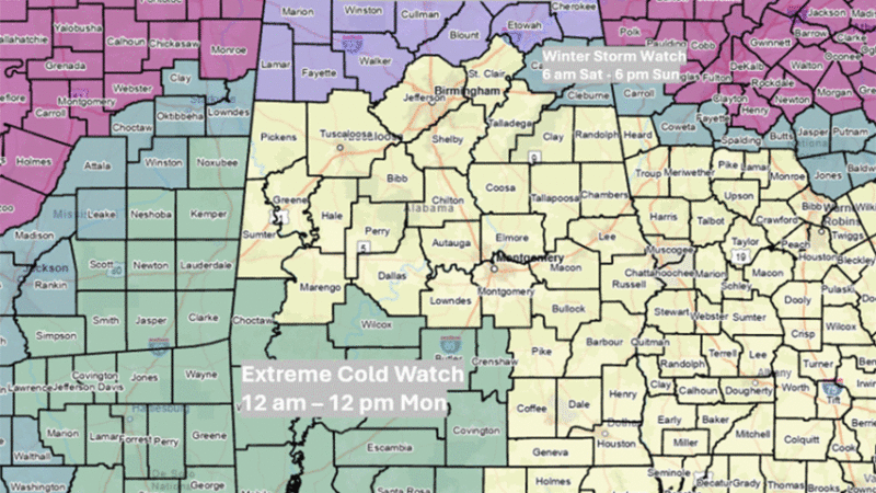
The Alabama Emergency Management Agency has issued an Ice Storm Warning for Lauderdale, Colbert, and Franklin counties from midnight Saturday until 6 p.m. Sunday. Winter Weather Advisories and a Winter Storm Watch are also in effect for areas near and north of Interstate 20 from early Saturday through Sunday evening. In addition, an Extreme Cold Watch has been posted for parts of southwestern Alabama from midnight to noon on Monday.
What’s Happening and When?
Precipitation is expected to begin reaching northern Alabama between 2 a.m. and 9 a.m. Saturday. Rain and wintry weather will then spread southward, covering most of the state by Saturday afternoon and evening. The bulk of the precipitation will taper off Sunday evening, but light snow flurries could linger into Monday morning.
Forecasters say northern Alabama could receive 2 to 4 inches of liquid-equivalent precipitation, with locally higher totals. These amounts raise concerns about localized flooding, particularly in low-lying or poorly drained areas. Southern Alabama is expected to receive 1 to 3 inches of rainfall.
Ice and Winter Travel Dangers
The most serious winter weather threat will be north of I-20. Freezing rain is expected to be the dominant precipitation type early Saturday, with some sleet possibly mixing in at the start. The worst icing is forecast for far northwestern Alabama, where ice accumulations could reach up to one inch by Saturday evening. That level of ice is capable of snapping tree limbs, downing power lines, and causing extended power outages.
Far northeastern counties could see up to a quarter-inch of ice. Areas closer to I-20 are expected to receive less than a tenth of an inch of freezing rain. While temperatures are forecast to rise above freezing across much of the state Saturday afternoon — which should help melt some ice — officials warn that roads north of I-20 could remain slick and dangerous well into the afternoon.
Drivers are strongly advised to avoid unnecessary travel in ice-affected areas, especially Saturday morning and early afternoon.
A Second Round of Winter Weather Sunday
Another unusual shift will occur Sunday afternoon as very cold air pushes into northwestern Alabama. This will likely change rain back to light freezing rain or snow across much of northern Alabama. Up to one inch of snow is possible in the far northwest, while most other northern areas may only see trace amounts or a light glaze of ice.
Although snowfall totals are not expected to be high, even small amounts of ice or snow could worsen already hazardous road conditions.
Severe Storms in the South
While the northern half of the state deals with winter weather, southern Alabama will face a different threat. From late Sunday morning through early Sunday evening, a line of showers and thunderstorms is expected to move through the southern half of the state.
Some of these storms could become severe, producing damaging wind gusts between 40 and 60 miles per hour. Forecasters also say one or two tornadoes cannot be ruled out during this time. Residents in southern Alabama should remain alert for rapidly changing conditions and be ready to seek shelter if warnings are issued.
Dangerous Cold Follows
Behind the storm system, an arctic air mass will settle over Alabama. By Monday morning, temperatures are expected to drop into the teens across northern counties and into the 20s farther south. Any leftover water on roads and sidewalks could refreeze, creating black ice.
Strong northwest winds will make conditions even more dangerous, with wind chills potentially falling to around minus 3 degrees in northern Alabama and into the teens in southern areas.
High temperatures on Monday are forecast to remain very cold, reaching only the 20s in the north and the lower 40s in the south. The cold will intensify Monday night, with lows Tuesday morning dropping into the single digits in northern Alabama and into the teens elsewhere. Highs on Tuesday are expected to reach only the mid-30s north and mid-40s south.
What Should I Do Now?
Emergency officials urge residents to take this multi-day weather threat seriously:
- Avoid unnecessary travel, especially in areas under Ice Storm Warnings or
- Winter Weather Advisories.
- Prepare for possible power outages by charging phones, gathering flashlights, and stocking food, water, and medications.
- Protect pipes from freezing and bring pets indoors.
- Monitor weather alerts and updates from trusted local sources.
“This is not a single hazard event — it’s several dangerous weather threats happening back to back,” officials said. “Ice, flooding, severe storms, and extreme cold all pose serious risks. Preparation now can prevent injuries and save lives.”
Residents are encouraged to stay informed and be ready to act as conditions evolve throughout the weekend and early next week.
